
Step outside and look around at the landscape surrounding you. What you see underneath your feet and under the buildings and roads is the terrain.
Deriving from the word terra, which means earth, terrain simply refers to the vertical and horizontal slopes of the surface, or land. When people talk about terrain, you’ll notice references to elevation, slope, and orientation of the land.
The terrain affects most aspects of our lives; from where it is habitable to live to weather patterns to water flow and distribution. Knowing about terrain is also useful for things like farming, military tactics, aviation, and soil conservation.
Now that you know what terrain is, it’s time to look at the types of terrain here on Earth. While the most common types of terrain are valley, plain, mountain, and plateau, we will be covering the 14 main terrain types. This also includes open, tundra, oasis, desert, swamp, forest, marsh, river, canyon, and hill terrains.
Valley
Valleys are a low lying terrain between hills or mountains that are a depressed area, which is geological terms is called a depression. Usually there is a river or stream running through a valley because that waterway is what carved out the valley.
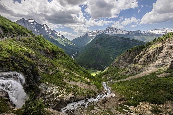
Valleys can go on for miles, or they may only exist at the foot of two mountains. Some valleys are V-shaped while others are U-shaped.
The bottom of a valley is called the floor, which can also be U-shaped or V-shaped. And the sides of a valley can be steep or gently sloping.
There are a few different types of valleys across the world. These include:
- River valley: These are valleys with water flowing through them.
- Rift valley: These usually have steep flat sides and are caused by divergent forces acting on the earth’s crust and pulling plates apart.
- Glacial valley: These are usually U-shaped and are common in the North and south poles. They are made by moving ice cutting through the slopes on which they slide. After the ice melts, dry valleys are left behind.
- Hanging valley: This is a tributary valley that is higher than the main valley. They are most commonly associated with U-shaped valleys when a tributary glacier flows into a glacier of larger volume.
- Trough-shaped valley: These are found in areas of heavy denudation, mainly in periglacial regions and in tropical regions of variable wetness.
- Box valley: These have wide, relatively level floors and steep sides and are usually found in periglacial areas and occur in mid-latitudes, but also occur in tropical and arid regions.
- Hollows: These are small stream beds or valleys This term is commonly used in Ireland, New England, Appalachia, and the Ozarks of Arkansas and Missouri.
Though they look similar, a canyon is not a type of valley.
Here are some common terms you might not be familiar with:
- Vale: A valley through which a river runs.
- Dell: A small, secluded and often wooded valley.
- Glen: A long valley bounded by gently sloped concave sides.
- Strath: A wide, flat valley through which a river runs.
- Mountain cove: A small valley, closed at one or both ends, in the central or southern Appalachian Mountains which sometimes results from the erosion of a geologic window.
- Hollow: A term used sometimes for a small valley surrounded by mountains or ridges.
- cwm (also spelled combe or coombe): A deep, narrow valley.
- A steephead valley is a deep, narrow, flat bottomed valley with an abrupt ending.
- Erosional valley: A valley formed by erosion.
- Structural valley: A valley formed by geologic events such as drop faults or the rise of highlands.[2]
- Dry valley: A valley not created by sustained surface water flow.
- Longitudinal valley: An elongated valley found between two almost parallel mountain chains.
- Denudation: This involves the processes that cause the wearing away of the Earth’s surface by moving water, by ice, by wind and by waves, leading to a reduction in elevation and in relief of landforms and of landscapes.
Canyon
Just like a valley, a canyon is a depressed area that typically has been carved out by water and is typically between mountains. Though at first glance it looks like valley, they are actually different types of terrain.

In fact, a canyon is deeper, more narrow and with steep sides. What’s interesting is that sometimes valleys contain canyons in them.
River canyon is the most common type of canyon. A good example of this is the famous Grand Canyon in Arizona.
Erosion and weathering also create canyons. Slot canyons are a good example of this type of canyon, which is characterized by smooth and difficult to climb sides.
Hard-rock canyons that are open at one end are called box canyons. The Hopi and Navajo people often used box canyons as natural corrals for livestock.
One really cool type of canyon is formed when limestone erodes and forms caves underground. And those cave ceilings collapse leaving awesome underground limestone canyons, which are often referred to as cave canyons.
Tectonic activity, which is the Earth’s shifting plates, also cause canyons to form in parts of the world. While the Colorado River has helped to carve the Grand Canyon, it was initially formed as the result of a tectonic uplift.
Submarine canyons, which are some of the deepest canyons on Earth, cut into continental shelves and continental slopes—the edges of continents that are underwater. These canyons were carved by rivers long before our time on Earth when the sea level was lower.
Powerful ocean currents can also sweep away layers of sediment to create submarine canyons. A good example of this is the Whittard Canyon, which is about 400 kilometers (248 miles) south of the coast of Ireland in the Atlantic Ocean.
Plain
Plain terrains are flat landmasses with little to no change in elevation that tend to go on for quite some distance. You can find plains in lowland areas, such as valleys, and as coastal plains, such as uplands or plateaus.
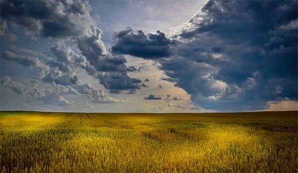
Here’s a cool fact: plains cover more than a third of the land area on Earth. And, you can find this landform on every single continent in the world.
Throughout most of the world, grasslands are the type of plains that exist. For example, the Great Plains stretches across a large swath of central North America and it is a grasslands.
Deserts and forests can also be plains. For instance, parts of the Sahara desert, in North Africa, are plains.
Plains can form from erosion, volcanic activity, and the movement of rivers. Alluvial plains form at the base of mountains as a result of water carrying sediment downhill until it hits flat land.
When rivers flood onto the surrounding land, they deposit sediment. As that sediment builds up over time, it creates what is known as flood plains. Flood plains are perfect for farmland due to the high amount of nutrients in the soil.
A coastal plain is form when a river deposits its sediment in the ocean, which builds up and eventually rises above sea level. If that rise above sea level happens, then you get a coastal plain.
Probably the coolest type of plain is the abyssal plain. Abyssal plains are only found at the bottom of the ocean, which means they are 5,000 to 7,000 meters (16,400 to 23,000 feet) below sea level. These plains are among the flattest, smoothest places on Earth.
Mountain
A mountain is a a type of terrain characterized by steeply rising ground. Mountains tend to have a good rise in elevation, with the minimum required height of 2,000 ft. needing to be met in order to be classified as a mountain.
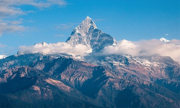
Mount Everest is the tallest mountain in the world at over 29,000 feet. And the tallest mountain in North America is Denali, which is in Alaska and measures in at over 20,000 feet.
You might be wondering – how are mountains measured? They can be measures from the very bottom to the very top of the summit; or the can be measured according to how much they are above sea level.
Curious about the differences between mountains and hills?
- Hills are easier to climb since they are not as high or as steep
- Hills are “bumps” in the land that are no higher than 2,000 feet
- Hills can be made by people – there are called mounds
- The U.S. Geological Survey states that there is no official difference between hills and mountains.
Plateau
A plateau is a flat, elevated landform that rises sharply above surrounding area on at least one side. You can find plateaus on every single continent on Earth and they make up a third of all the Earth’s land.
There are two kinds of plateaus: dissected plateaus and volcanic plateaus.
Dissected plateaus form as a result of upward movement in the Earths crust. Volcanic plateaus are formed by numerous small volcanic eruptions that slowly build up over time, forming a plateau from the resulting lava flows.
The shape of a plateau can be influenced by natural erosion over time. Plateaus in the ocean are divided into two types. One is made of continental crust and the other is made of igneous rock.
Cool fact: The largest plateau in the world is the Tibetan Plateau, which is located in central Asia. This plateau is located in parts of Tibet, China, and India and occupies an area of 2.5 million square kilometers (1.5 million square miles). That makes it four times the size of the U.S. state of Texas!
Open
Open terrains are flat and open areas of land, such as grasslands. By its definition, an open terrain must be free of any obstructions, such as buildings or trees.

Open terrain is also known as open country and open ground.
An open terrain does not have to be naturally occurring. In fact, an area of land that has been cleared of obstruction, such as a landing strip for a plane or an airport itself, is considered open terrain.
Open terrain play an important part of the military since it is used for maneuvers and tactics due to the lack of obstacles.
One important characteristic of an open terrain is the wind. With no obstacles on the land, wind loading is high since there’s nothing to break the wind.
Tundra
Tundra terrains are flat, treeless, cold, and often frozen wastelands. They are typically found on the tops of mountains, where the climate is cold and windy, and rainfall is scant.

What’s interesting about tundra is that it is covered in snow and ice most of the year, but can bright up with wildflowers in the summer months. There are three regions and associated types of tundra: Arctic tundra, alpine tundra, and Antarctic tundra.
- Arctic tundra: this type of tundra is found mostly in the far northern hemisphere. It is frozen most of the year. Due to the harsh climate of Arctic tundra, regions of this kind have seen little human activity.
- Alpine tundra: this type of tundra is usually found in high altitudes in mountains across the world. It is very cold and windy, which means no tree growth. It is distinguished from arctic tundra in that alpine tundra typically does not have permafrost, and alpine soils are generally better drained than arctic soils.
- Antarctic tundra: this type of tundra is found in Antarctica and on several Antarctic and subantarctic islands. In contrast with the Arctic tundra, the Antarctic tundra lacks a large mammal fauna.
Oasis
Oasis is a flat desert located near water. What makes it unique in the desert landscape is that it is made fertile by a source of freshwater in an otherwise dry and arid region.

More than one oasis is called an oases. An oasis can vary greatly in size – from a cluster of palms around a natural spring to a city and its irrigated cropland.
What’s interesting about an oasis is that even though it’s in a desert, crops can grow and thrive on the land. Common crops that grow well in an oasis are: cotton, dates, olives, corn, citrus fruits, wheat, and figs.
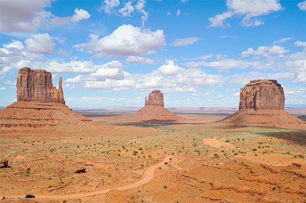
Desert
A desert is a barren terrain characterized by sandy and arid ground. There’s not much precipitation in the desert, which means that it doesn’t support much plant life or wildlife.
That being said, the desert is home to a variety of plants, animals, and other organisms. These are things that throughout time have adapted to the harsh conditions of the terrain.
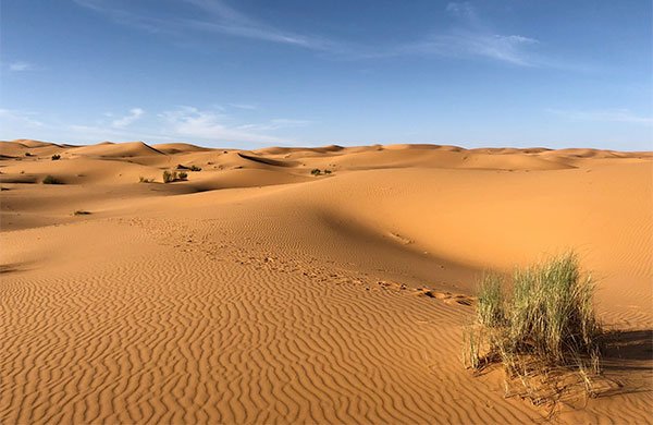
It’s a common misconception that deserts are hot. While many of them are incredibly warm, there are some deserts that are not only cold in the winter but that are cold all year long.
To be classified as a desert, experts agree that the definition is an area of land that receives no more than 25 centimeters (10 inches) of precipitation a year. You can find deserts on every continent on Earth; and they cover around 20% of the Earth’s land.
While most people think of sand dunes when they think of the desert, not all deserts are made up of dunes. Some have mountains, salt flats, and rock.
There are five types of deserts, based on what causes the terrain to be dry. Those types are:
- subtropical – caused by the circulation patterns of air masses.
- coastal – caused by the cold ocean currents.
- rain shadow – these are near the leeward slopes of some mountain ranges. Leeward slopes face away from prevailing winds. When moisture-laden air hits a mountain range, it is forced to rise. The air then cools and forms clouds that drop moisture on the windward (wind-facing) slopes. When the air moves over the mountaintop and begins to descend the leeward slopes, there is little moisture left. The descending air warms up, making it difficult for clouds to form.
- interior – found in the heart of continents, exist because no moisture-laden winds reach them.
- polar – Parts of the Arctic and the Antarctic are classified as deserts. These polar deserts contain great quantities of water, but most of it is locked in glaciers and ice sheets year-round. So, despite the presence of millions of liters of water, there is actually little available for plants and animals.
Cool fact: The largest desert in the world is also the coldest. Almost the entire continent of Antarctica is a polar desert, experiencing little precipitation. Few organisms can withstand the freezing, dry climate of Antarctica.
Swamp
Swampy areas are characterized as muddy and with very wet grounds. There are usually trees in the swamp, making it a forested wetland. In fact, the terrain is dominated by the trees and water.
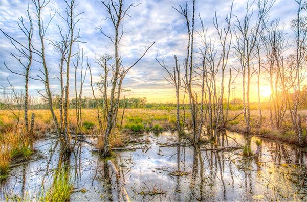
There are two main types of swamps: freshwater swamps and saltwater swamps. Freshwater swamps are found inland while saltwater swamps are found in coastal locations.
Generally, a swamp is named based on the types of trees in it, such as hardwood swamps. And you can find swamps on every continent except for Antarctica.
Swamps vary in size from small to very large. Some swamps are lakes that were overtaken by trees; and some are wetlands that flooded.
Forest
Forests are filled with many trees and usually not really populated by people. Sure, some forests have areas with cabins and such, but for the most part it’s just trees, animals, and other plant life.
Scientists think that around one third of the land on Earth is covered by forests. There are three main types of forests: tropical, temperate, and boreal.
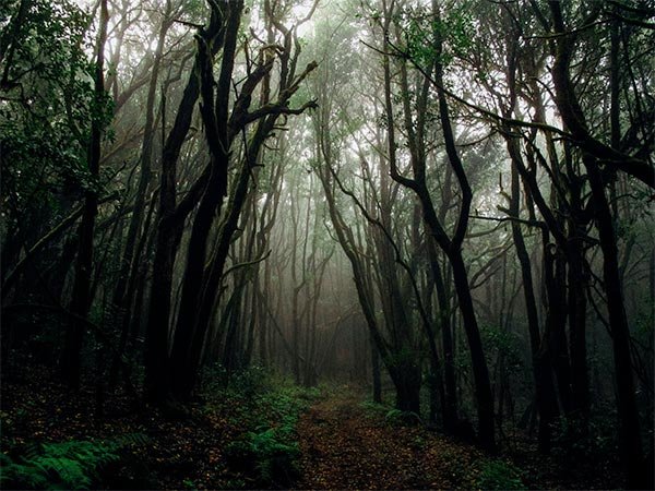
Tropical forests are found in areas near the equator; and tropical rainforests are in this category. In the tropics and subtropics you’ll also find tropical mangrove forests, which are characterized by trees and shrubs that grow in salty or brackish water.
Temperate forests have four distinct seasons and are found throughout Eurasia and North America. This type of forest has a lot of precipitation, which leads to a lot of flora and fauna.
Boreal forests, which are also known as taiga, are found throughout Siberia, Scandinavia, and North America (Alaska and Canada). This type of forest is one of the world’s largest land biomes.
Temperatures in boreal forests average below freezing, which means lots of needle leaf plants thrive here. This type of forest also plays a significant role in removing carbon dioxide from the Earth’s atmosphere.
Marsh
Marshy terrain is a wetland characterized by soft and wet ground. Unlike a swamp, a marsh is characterized by herbaceous (grasses, reeds, and rushes) rather than woody plant species growing on the land.
You’ll find marshes located at the edges of streams and lakes, where they function as a transition between the terrestrial and aquatic ecosystems. There are three types of marshes: saltwater marsh, freshwater marsh, and freshwater tidal marsh.
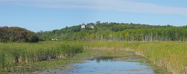
As you can see, the type of marsh is determined by salinity and location. Overall, you can find marshes all over the world.
Saltwater marshes are typically found along areas of protected coastline at mid to high latitudes. Being close to the shorelines means that the tides affect these marshes, and sometimes they get covered by water.
Freshwater marshes are the most common type of wetland in North America; and they are the most diverse type of marsh on Earth. The types of freshwater marshes include: wet meadows, vernal pools, playa lakes, prairie potholes, and riverine wetlands.
Freshwater tidal marshes are just a freshwater marsh that is affected by the tides. But since there is no salinity in the water, this type of tidal marsh has more biodiversity than a saltwater marsh.
Some tidal marshes have been embanked and artificially drained. These are known as embanked marshes, or by the Dutch term polders.
Wondering what the difference is between a marsh and a bog? A marsh is different from a bog because bogs have poor soil and high peat content.
River
Rivers are broad areas of running water that flow downhill due to the force of gravity. Some rivers are only flowing part of the year or only when it rains, while others flow all year long.
Rivers come in all sizes – they can be small and shallow or wide and deep. Flowing water that is smaller than a river is a stream, brook, or creek.
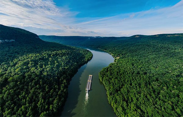
The water in rivers is fresh water, which means that it has less than one percent of salt in it. However, rivers can still carry salt (and other important nutrients for plant and animal life).
When rivers meet the ocean, they form an estuary, which is when salty seawater mixes with fresh water near the river mouth to form brackish water.
The starting point of a river is called the headwater. And the end of the river is called the mouth.
Headwater often comes from snowmelt or rainfall in the mountains, but an also come from groundwater. As a river flows, it may pass through wetlands, which act as a filter to remove pollutants from the flowing water.
Hill
Hill terrain is a gently rising land, often referred to as a bump. Hills can be formed naturally or by people. When formed by people, they are called mounds.
Geological activity, such as faulting, creates natural hills in the landscape. Faulting happens because the rocks underneath the Earth’s surface are constantly moving and changing the landscape.

And over time, hills created by faulting turn into mountains. Though the U.S. Geological Survey states that there is no official difference between hills and mountains.
Erosion can both naturally create and destroy hills. In fact, a mountain can be worn down by erosion and turn into a hill.
Here are the types of hills:
- Drumlin: this is a long hill formed by the movement of glaciers.
- Butte: this is a hill that usually stands alone in a flat area. It has steep sides and a flat top.
- Tor: this is a rock formation on top of a hill. Though in some places, like the United Kingdom, tor refers to the hill itself.
- Puy: this is a cone-shaped, volcanic hill.
- Pingo: this is a mound of ice covered with earth, which are found in the Arctic and Antarctica.
- Mesa: this is a flat-topped hill or mountain.
image credits: 1, 2, 3, 4, 5, 6, 7, 8, 9, 10, 11, 12, 13, 14, 15